<<< back< prevnext >
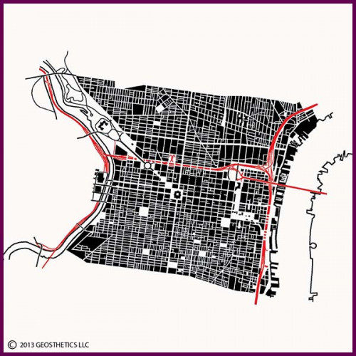 Philadelphia was one of the earliest pre-planned cities of the British American colonies. The city was laid out between the Delaware River and Schuylkill River in southeast Pennsylvania by William Penn in 1682, shortly after he received a very large land grant from King Charles of England. The layout consisted of a central square, from which two wide streets emanated: Broad Street, which runs generally north and south, and Market Street, which runs generally east and west. A grid of streets created large blocks in which were envisioned sizable lots for homes and gardens. In addition to the central square, four other public squares were laid out, today known as Logan Square to the northwest, Franklin Square to the northeast, Washington Square to the southeast, and Rittenhouse Square to the southwest.
Though the central square, known as Penn Square, was intended as the primary focus of the city, Philadelphia developed first along the Delaware River to the east, which was the location of the docks and wharves from which colonial trade occurred through Delaware Bay and the Atlantic Ocean. The city then expanded westward, enveloping Penn Square in the 19th Century. Today, downtown is now focused around City Hall, built in 1901 on William Penn's central square.
The city's large blocks were quickly subdivided into smaller blocks as the city developed. This can be seen in today's plan of the city's streets, where smaller lanes and alleys break up the larger blocks, creating a sub-pattern of long and narrow blocks on which many of the city's famed townhouses were built. North and south of the original town plan can be seen a number of streets and uniquely shaped blocks that run at various angles to the original street grid. These developed from the loose pattern of farm fields and country lanes that crisscrossed the region outside of the original town plan.
Running diagonally to the northwest of City Hall, through Logan Square, is the Benjamin Franklin Parkway. This boulevard was planned in 1917 as part of the City Beautiful movement, during which grand planning gestures were often integrated into the often downtrodden existing urban fabric as an attempt to improve the vitality of cities. At the northwest end of the boulevard sits the city's renowned Philadelphia Museum of Art, which is at the south end of Fairmount Park.
West of downtown, across the Schuylkill River, are the city's 30th Street Station and historic Central Post Office. East of downtown is the Benjamin Franklin Bridge, which runs from Franklin Square eastward to Camden, New Jersey. South of the Benjamin Franklin Bridge approach lies the Independence Mall, at the south end of which is Independence Hall, built originally as Pennsylvania's colonial State House and renowned as the original home of the Liberty Bell and as the location where the Declaration of Independence was approved by the Second Continental Congress.
Merchandise:

Philadelphia
Description:Philadelphia was one of the earliest pre-planned cities of the British American colonies. The city was laid out between the Delaware River and Schuylkill River in southeast Pennsylvania by William Penn in 1682, shortly after he received a very large land grant from King Charles of England. The layout consisted of a central square, from which two wide streets emanated: Broad Street, which runs generally north and south, and Market Street, which runs generally east and west. A grid of streets created large blocks in which were envisioned sizable lots for homes and gardens. In addition to the central square, four other public squares were laid out, today known as Logan Square to the northwest, Franklin Square to the northeast, Washington Square to the southeast, and Rittenhouse Square to the southwest.Though the central square, known as Penn Square, was intended as the primary focus of the city, Philadelphia developed first along the Delaware River to the east, which was the location of the docks and wharves from which colonial trade occurred through Delaware Bay and the Atlantic Ocean. The city then expanded westward, enveloping Penn Square in the 19th Century. Today, downtown is now focused around City Hall, built in 1901 on William Penn's central square.
The city's large blocks were quickly subdivided into smaller blocks as the city developed. This can be seen in today's plan of the city's streets, where smaller lanes and alleys break up the larger blocks, creating a sub-pattern of long and narrow blocks on which many of the city's famed townhouses were built. North and south of the original town plan can be seen a number of streets and uniquely shaped blocks that run at various angles to the original street grid. These developed from the loose pattern of farm fields and country lanes that crisscrossed the region outside of the original town plan.
Running diagonally to the northwest of City Hall, through Logan Square, is the Benjamin Franklin Parkway. This boulevard was planned in 1917 as part of the City Beautiful movement, during which grand planning gestures were often integrated into the often downtrodden existing urban fabric as an attempt to improve the vitality of cities. At the northwest end of the boulevard sits the city's renowned Philadelphia Museum of Art, which is at the south end of Fairmount Park.
West of downtown, across the Schuylkill River, are the city's 30th Street Station and historic Central Post Office. East of downtown is the Benjamin Franklin Bridge, which runs from Franklin Square eastward to Camden, New Jersey. South of the Benjamin Franklin Bridge approach lies the Independence Mall, at the south end of which is Independence Hall, built originally as Pennsylvania's colonial State House and renowned as the original home of the Liberty Bell and as the location where the Declaration of Independence was approved by the Second Continental Congress.