<<< back< prevnext >
 Washington, District of Columbia, is the federal capital of the United States of America. Arguably the most famous pre-planned city, the initial layout of the capital city was conceived by Pierre Charles L'Enfant, a military engineer of French heritage during the American Revolutionary War, in 1791. The capital site, chosen by George Washington at the request of Congress, lies on the east bank of the Potomac River and north of the Anacostia River, with the northern boundaries formed by diagonal lines running northwest from the Anacostia River to a rise in the land along the northwest limits of the site. The port community of Georgetown existed on the Potomac immediately west of the capital site, across Rock Creek.
The primary focal points of L'Enfant's plan were the President's House (White House), sited in the northwest portion of the city, and the Capitol building, which was located on a rise in the east central part of the city. Extending from these two locations, southward from the President's House and westward from the Capital, were grand public spaces that intersected at the Potomac. Laid out around these primary points of interest was a dynamic pattern of streets, with European style grand diagonal boulevards emanating from the President's House, Capitol, and numerous rectangular and circular public spaces overlaid onto a non-uniform grid of streets, creating a uniquely recognizable pattern across the plan.
L'Enfant's plan has been generally maintained throughout the city's two centuries, and is identifiable in the image showing the current historic city, stretching from Georgetown to the west to the Anacostia River to the southeast. The White House, with its adjacent Old Executive Office Building and Treasury Building, and the Capitol are connected by the prominent diagonal boulevard known as Pennsylvania Avenue, which has become the nation's ceremonial street for presidential inaugural parades. The grand public spaces of the plan are known today as the President's Park, which includes Lafayette Square north of the White House and the Ellipse to the south of the White House, and the National Mall, which extends westward from the Capitol. Today's park areas along the Potomac were created by infilling the tidal areas of the broad river, and include land upon which are located the Lincoln Memorial at the west end of the Mall, the reflecting pool to the east of the memorial, the land surrounding the graceful Tidal Basin, and the tapering East Potomac Park island to the south of the basin. Sitting at the north end of this island is the Jefferson Memorial, overlooking the Tidal Basin and aligned with the White House to the north. The famed Washington Monument obelisk sits at the intersection of these grand public spaces.
The National Mall today is an important public space for the American people, being used for many of the nation's significant celebrations, commemorations, peaceful assemblies, and inaugurations. The mall is flanked along its north and south borders by some of the nation's most famous and prominent museums.
Other significant features shown in the image include the Supreme Court and Library of Congress, both of which sit just east of the Capitol, Washington's famed Union Station northeast of the Capitol, the Robert F. Kennedy Stadium and adjacent D.C. Armory at the end of the Capitol's east axis, and the Nationals Park stadium at the end of the Capitol's south axis.
Merchandise:

Washington DC
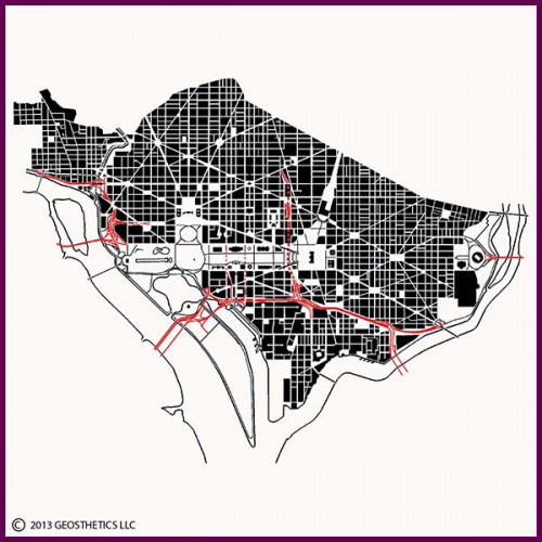
Description:Washington, District of Columbia, is the federal capital of the United States of America. Arguably the most famous pre-planned city, the initial layout of the capital city was conceived by Pierre Charles L'Enfant, a military engineer of French heritage during the American Revolutionary War, in 1791. The capital site, chosen by George Washington at the request of Congress, lies on the east bank of the Potomac River and north of the Anacostia River, with the northern boundaries formed by diagonal lines running northwest from the Anacostia River to a rise in the land along the northwest limits of the site. The port community of Georgetown existed on the Potomac immediately west of the capital site, across Rock Creek.
The primary focal points of L'Enfant's plan were the President's House (White House), sited in the northwest portion of the city, and the Capitol building, which was located on a rise in the east central part of the city. Extending from these two locations, southward from the President's House and westward from the Capital, were grand public spaces that intersected at the Potomac. Laid out around these primary points of interest was a dynamic pattern of streets, with European style grand diagonal boulevards emanating from the President's House, Capitol, and numerous rectangular and circular public spaces overlaid onto a non-uniform grid of streets, creating a uniquely recognizable pattern across the plan.
L'Enfant's plan has been generally maintained throughout the city's two centuries, and is identifiable in the image showing the current historic city, stretching from Georgetown to the west to the Anacostia River to the southeast. The White House, with its adjacent Old Executive Office Building and Treasury Building, and the Capitol are connected by the prominent diagonal boulevard known as Pennsylvania Avenue, which has become the nation's ceremonial street for presidential inaugural parades. The grand public spaces of the plan are known today as the President's Park, which includes Lafayette Square north of the White House and the Ellipse to the south of the White House, and the National Mall, which extends westward from the Capitol. Today's park areas along the Potomac were created by infilling the tidal areas of the broad river, and include land upon which are located the Lincoln Memorial at the west end of the Mall, the reflecting pool to the east of the memorial, the land surrounding the graceful Tidal Basin, and the tapering East Potomac Park island to the south of the basin. Sitting at the north end of this island is the Jefferson Memorial, overlooking the Tidal Basin and aligned with the White House to the north. The famed Washington Monument obelisk sits at the intersection of these grand public spaces.
The National Mall today is an important public space for the American people, being used for many of the nation's significant celebrations, commemorations, peaceful assemblies, and inaugurations. The mall is flanked along its north and south borders by some of the nation's most famous and prominent museums.
Other significant features shown in the image include the Supreme Court and Library of Congress, both of which sit just east of the Capitol, Washington's famed Union Station northeast of the Capitol, the Robert F. Kennedy Stadium and adjacent D.C. Armory at the end of the Capitol's east axis, and the Nationals Park stadium at the end of the Capitol's south axis.