<<< back< prevnext >
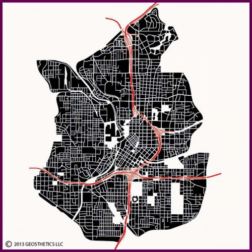 This central area image shows Atlanta's intriguing street pattern, primarily consisting of a series of loose grids of varying block sizes. The downtown area, located to the left of the arcing north-south I-75/85 freeway, consists of several grids rotated at various angles to the cardinal points. The rotated grids were laid out in relation to the three railroads that converged here. These railroads set the stage for the founding of Atlanta. The other grids, generally laid out to the cardinal directions, were developed as Atlanta grew.
Midtown Atlanta is immediately north of downtown, just across and running alongside the I-75/85 freeway. The curving streets at the north end of this image identify the upscale Ansley Park neighborhood, developed in the 1920's.
Atlanta has also had large sections of the city reconfigured to accommodate large-scale projects. Atlanta's freeways, which intersect just south of downtown, were completed in the 1960's. The now-demolished Fulton County Stadium, built in the 1960's, and its adjacent 1996 baseball stadium replacement, Turner Field, are located just south of the central interchange. The massive Georgia World Conference Center/Georgia Dome/Phillips Arena/CNN Center complex was built in the neighborhood immediately west of Downtown starting in the mid-1970's, and the Centennial Olympic Park and the adjacent Georgia Aquarium/World of Coca Cola complexes were built in the northwest quadrant of downtown starting in the 1990's.Merchandise:

Atlanta
Description:This central area image shows Atlanta's intriguing street pattern, primarily consisting of a series of loose grids of varying block sizes. The downtown area, located to the left of the arcing north-south I-75/85 freeway, consists of several grids rotated at various angles to the cardinal points. The rotated grids were laid out in relation to the three railroads that converged here. These railroads set the stage for the founding of Atlanta. The other grids, generally laid out to the cardinal directions, were developed as Atlanta grew.Midtown Atlanta is immediately north of downtown, just across and running alongside the I-75/85 freeway. The curving streets at the north end of this image identify the upscale Ansley Park neighborhood, developed in the 1920's.
Atlanta has also had large sections of the city reconfigured to accommodate large-scale projects. Atlanta's freeways, which intersect just south of downtown, were completed in the 1960's. The now-demolished Fulton County Stadium, built in the 1960's, and its adjacent 1996 baseball stadium replacement, Turner Field, are located just south of the central interchange. The massive Georgia World Conference Center/Georgia Dome/Phillips Arena/CNN Center complex was built in the neighborhood immediately west of Downtown starting in the mid-1970's, and the Centennial Olympic Park and the adjacent Georgia Aquarium/World of Coca Cola complexes were built in the northwest quadrant of downtown starting in the 1990's.