Detroit
Description: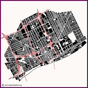 Detroit is the heart of and synonymous with the American automobile industry. The city was originally founded as a French fort and settlement in 1701. The fort was captured by the British in 1760, and became part of America in 1796. The settlement was destroyed by fire in 1805.
After the fire, the city was re-planned by Augustus Woodward as a series of dynamic, interconnected circular public spaces with radiating streets and blocks, with rectangular public spaces at major intersections of the radial streets. A small portion of this concept was executed, and can be seen in the city's downtown. However, the city's residents soon expanded using the more typical street grid system. The Woodward layout was the basis for Detroit's major radiating boulevards which stretch across the city's grid today.
Detroit saw tremendous growth in the early half of the 20th Century, and by mid-century the Motor City planned and built an extensive freeway system. However, that growth significantly reversed in the latter half of that century. In response, large areas of the city were reconfigured in various attempts to remake the city, which can be seen by the large areas where smaller blocks were consolidated into large "super-blocks".
The City is joined to Canada to the south by the Ambassador Bridge, shown in the left portion of the image, the Detroit-Windsor Tunnel, shown in the middle portion of the image, and a railroad tunnel whose approach runs diagonally across the city just east of the Ambassador Bridge. At the top of this railroad approach is the city's grand Michigan Central Station, which used to be the city's primary passenger rail station, but today sits unused.